<b>Schuur</b>, E. A. G., A. D. <b>McGuire</b>, V. <b>Romanovsky</b>, C. Schädel, and M. Mack, 2018: Chapter 11: Arctic and boreal carbon. In Second State of the Carbon Cycle Report (SOCCR2): A Sustained Assessment Report [Cavallaro, N., G. Shrestha, R. Birdsey, M. A. Mayes, R. G. Najjar, S. C. Reed, P. Romero-Lankao, and Z. Zhu (eds.)]. U.S. Global Change Research Program, Washington, DC, USA, pp. 428-468, https://doi.org/10.7930/ SOCCR2.2018.Ch11.
Arctic and Boreal Carbon
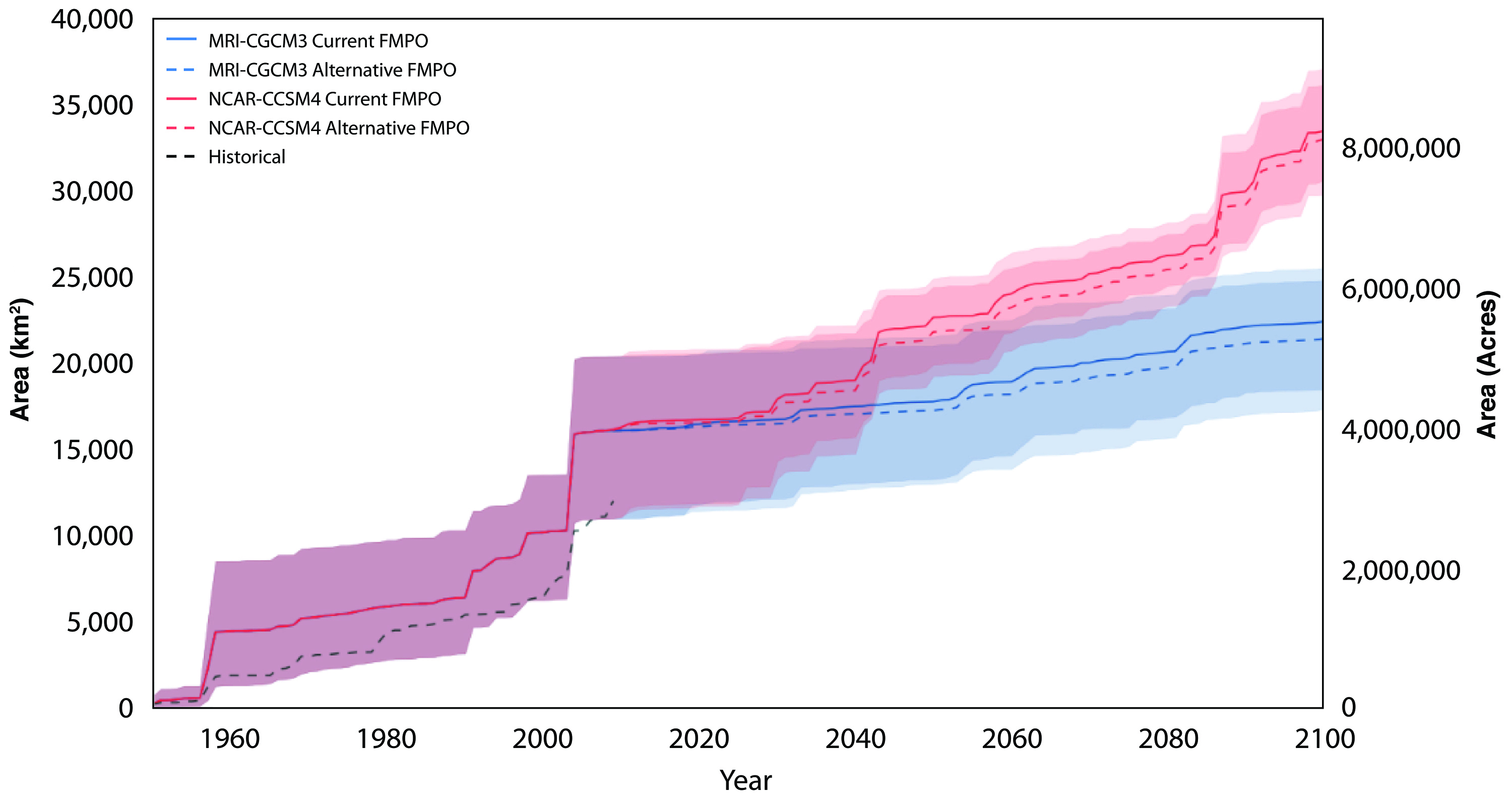
Forestry is the most widespread human management activity that affects the carbon cycle in the most productive and accessible portion of the boreal forest. This section focuses on a case study of how wildfire management in Alaska has the potential to affect the fire cycle and, consequently, carbon pools via pathways described earlier in the chapter. In Alaska, all lands are classified into fire management planning options depending on the proximity to and density of human infrastructure. The range of management options include “Limited” (i.e., the least amount of management where fire activity is largely observed but not suppressed), “Modified,” “Full,” and “Critical” (i.e., assigned to lands immediately surrounding human settlements and key infrastructure and resources). Each option represents an increasing amount of human intervention to suppress wildfire activity. This case study describes a modeling experiment conducted to determine the impact of changing fire management planning options from the current designation of Limited or Modified to Full protection for all military lands in the greater Fairbanks, Alaska, area. This change in fire management led to a small increase in the projected number of fires per decade because more flammable vegetation (e.g., late successional conifer forests) would be preserved, but, importantly, there was a projected decrease in the cumulative area burned through 2100 compared to the status quo (see Figure 11.8). Depending on the particular climate projection, active fire management (Full) decreased the projected cumulative area burned by 1.5% to 4.4% by 2100 (Breen et al., 2016). Differences in projected climate by 2100 arising from different climate model formulations have a strong impact on cumulative area burned, but fire management does have a small effect no matter the actual climate realized at the end of the century. In the absence of changing fire severity, the effect on carbon emissions would be exactly proportional to the difference in area burned. However, the somewhat small difference in cumulative area burned, and the proportional resulting effect on the carbon cycle, would need to be considered in context with the additional resources required to change the fire management planning option from the lower to higher level.
Figure 11.8: Effects of Two Climate Scenarios and Two Management Scenarios for a Subregion of Alaska